9 Feb
We are three weeks in and flowers should be pushing away the pearls.
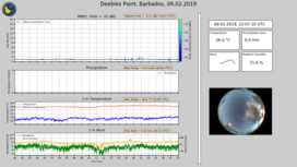
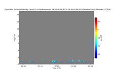
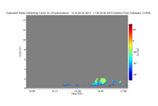
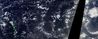
I was watching my purported wave (Sandrine’s string of cold-pool pearls) and hoping for some fireworks at the site this morning (say around 12 UTC) but seemed to materialize. Look at Fig 1. which shows the radar and the winds, there is nothing going on. But now look closely.. there is a tiny weeny yellow polka dot… cumulini cluster at around 7 UTC and another maybe at 17 UTC, 10 hours later. Low level winds are about 5m/s so 10 hr is about 180 km if things move with the winds. Well, how tiny are the clouds? … pretty unimpressive as Figs 2 and 3 show, as blow-ups for the 7UTC and 17 UTC feature respectively. Trust me, or look for yourself, looking at other times makes these the most impressive game in town.
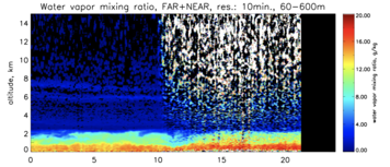
Looking at the lidar, one sees that these are modulated by a nice envelope in moisture, or rather one sees the collapse of the marine layer and intruding dry air separating these moist envelopes. This is shown in Fig. 4. The lidar is a Raman system, it is pretty powerful and very cool, but it doesn’t like stray sunlight, so there is more noise under Apollo;s gaze — just in case you wonder why it becomes more speckled centered around local noon (16 UTC).
So my claim is that there is a large-scale modulation with a scale of about 150km - 200 km that explains the variability in clouds… maybe if you are generous you would say there is a tiny hint of a signature in the wind field (increasing winds at around 7 and 16 UTC … (but also at some other times).
Worldview makes the story more complicated.. it beautifully decorates the wave-crests with strings of clouds, but near Barbados the picture get blurrier. There seems to be a line over the windward islands, which are leeward of Barbados, that is St Vincent which is nearest, 180 km to the East… but the next feature seems rather further east of Barbados than the 2.5 hrs or so that we would expect with the 17 UTC puff. But as one moves easterward the picture gets clearer, as the field of view goes from 40W to 65 W and the crests seem separated by about 300 km. And therein lies my problem… 300 km is more like 17 hours, i.e., i’d be expecting a puff about now, at 24 UTC… is 150 km a harmonic … or is Barbados too far south?
Well I haven’t looked at the nighttime GOES so I don’t know whats out there; but lets look at around 24 UTC, i.e., in 1-2 hrs and see if any of these ramblings have anything to them … given that its in the heart of saturday night ..
Thanks for this mesmerizing video Bjorn, Sandrine already sent this picture to some of us yesterday, the "cold pool necklace" as she said.
First, I didn’t know that high level westerlies were so prominent in this region. Is this well known ? In her study of the diurnal cycle, Jessica saw such westerlies in the NARVAL simulation over the Barbados domain (with ICON LEM) and she noticed that when deep convection events were crossing the domain, the westerlies tend to propagate downward, and even sometimes just up to the PBL. She read that, apparently, this could be due to westerly momentum transport by deep convection.
Here may have some deep convection in the western part of the domain, from which highest clouds are transported eastward by the strong westerlies aloft. As we know that shear strongly organizes deep convection, it could be somewhat similar here for shallow convection, since cold pools are aligned, forming a chain, as in a typical squall-line geometry. To sum up, deep convection could transport wind shear downward and help to organize shallow convection. I admit it is a bit twisted ...
Second, at the center of every "cloud hole » we have these sustaining low-level clouds, whose life cycle « seems" synchronized with the cloud holes they are attached to. It would be nice to measure that their typical lifecycle scales the typical autocorrelation timescale of w (about 3 hrs according to Bony and Stevens, 2018). To quantitatively estimate the life-cycle of these cloud holes should be feasible from satellite pictures ??? Just looking to the attached movie, 3 hrs looks reasonable … but this is very subjective.
Cheers,
Nicolas
Dear Nicolas,
just quickly on the westerlies; that is one of the things that makes summer and winter different. In winter thermal wind (cooling NH SSTs) gives you westerlies shear that is sufficiently strong that westerlies become inevitable, and usually the zero wind line is around the triple point. Attached is a plot (from a paper I am working on and off again with students and postdocs, this one Heike and Markus contributed to, among others). Here Barbados would be in the Western domain.
The point that I found surprising is that a deep layer of easterlies does not extend into the southern hemisphere in boreal winter, i.e., there is a north-south asymmetry, but this likely is just an expression of the asymmetry in the SSTs.
Cheers, Bjorn