Research Vessel Maria S Merian
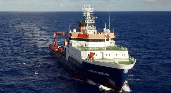
During the EUREC4A campaign the R/V Maria S. Merian will operate in regions where strong mesoscale ocean eddies are identified. It will perform radio-sonde launches, complementing the upper air network, but its main focus will be to study atmospheric oceanic interactions as mediated by ocean mesoscale eddies. Given the interest in ocean eddies it carries a fuller complement of instrumentation for measuring the upper ocean. A second objective is to use state-of-the art Largrangian cloud measurements with a CloudKite carrying advanced microphysical instrumentation. The cloud measurements will be contextualized by surface zenith pointing remote sensing and the radio-sondes. Atmospheric and oceanic measurements will be coordinated with other participating research vessels (R/V Meteor, RV L’Atalante, R/V Ron Brown, and possible Barbadian vessels), but particularly with the L'Atalante which shares similar scientific objectives. Current plans have the R/V Maria S. Merian arriving at Bridgetown, Barbados on 14 January, 2020 and departing on the morning of the 17th. While in harbor it will offloads instruments to be picked up by the R/V Meteor and collect supplies, instruments, and crew members for its crew.
Instrumentation:
| CTD–O2 water sampling rosette | conductivity, temperature, pressure, oxygen, photosynthetically active radiation (PAR), colored dissolved organic matter (CDOM), fluorescence, turbidity, nitrate (PI: Karstensen) |
| uCTD / rapid cast | Six-twelve times daily (minimum) Vaisala RS41-SGP radiosondes measuring pressure, temperature, humidity and GPS position (Claudia Stephan, MPI-M). |
| The microstructure sonde (MSS) measures profiles of micro-scale velocity shear, and temperature, O2 and turbidity fluctuations to determine the strength of turbulence in the water column. (PI: Dengler) | |
| A camera designed to image particles and plankton within the size range of 50 µm and 2 cm, mounted on the CTD-Rosette. It takes images of a 1 L illuminated volume (20 Hz). Particles/plankton > 0.5 mm are identified (PI: Kieko) | |
| X-Band radar | The 9.4 GHz X-Band wave radar measuring both phase and intensity of the radar backscatter sampled up to a maximum range of ca. 3 km (PI: Horstmann) |
| CARTHE drifters | CARTHE drifters consist of two interlocking drogue panels, a flexible rubber tether, and a float with an integrated GPS transmitter and battery. The drogue is centered at a depth of 0.40 m. (PI: Horstmann) |
| Ferrybox | Underway sensor package Ferrybox will sample near surface (ca. 6m WD) CO2 partial pressure and temperature in 1 Hz reolution (PI: Landschützer) |
| Thermosalinograph (TSG) | Underway sensor package to sample near surface (ca. 6m WD) temperature and salinity in 1 Hz resolution (PI: Karstensen) |
| Slocum underwater electric glider | measure CTD/O2, microstructure, shear and temperature, chlorophyll a, nitrate, turbidity, optical coloured dissolved organic matter, and fluorescence (PI: Krahmann) |
| Discrete water sampling | at CTD-O2 stations water is sampled at selected depth for oxygen, biogeochemical parameters (incl. nutrient concentrations) and other parameters (PI: Mohr) |
| Incubation | Primary productivity and N2 fixation via incubation experiments on water samples, and Microbial community structure sampling (PI: Mohr) |
| Moving vessel profiler | The Moving Vessel Profiler (MVP) is a streamlines buoy towed behind the ship at a speed of 3 - 6 knots. It will be used to survey the upper 250 m of the water column for its stratification (Temperature, Salinity) (PI: Karstensen) |
| Surface drifters | Surface drifters will be deployed to get an estimate of the surface currents (PI: Karstensen/E-surfmar) |
| Multibeam echosounders | Multibeam echosounders (EM712, EM122) will be used for underway bathymetric measurements ((PI: Wölfi)) |
| Ammonia oxidation | Volumetric rates of ammonia oxidation will be determined from seawater sampled from the CTD and with the use of stable isotope tracers (15N) (PI: Morh) |
| Saildrones | Saildrone vehicles, equipped with a small meteorological station, a physics/biogeochemical sensor package (T, S, O2, pCO2, chlorophyll/ turbidity), ADCP (currents) and zooplankton detector will be operated (PI: Karstensen) |
| Cloudkite (unmanned aerial vehicle) | The Max Planck Cloudkite equipped with an advanced cloud-particle imaging systems, and infrared and video camera system. The cloudkite will be operated within near range of the vessel profiling clouds up to 2 km above the surface (PI: Bodenschatz) |
| Cloud radar | A 94 Ghz (W-band) Frequency-Modulated Continuous-Wave (FMCW) Radar will obtain vertical profiles (150 m to 10 km above ground) of reflectivity, Doppler velocity, Doppler spectral width. This information is used to estimate macrophysical (cloud boundaries, type of cloud particles), and microphysical (e.g., liquid and ice water content) properties of clouds, and the integrated amount of liquid water (ILW) in the atmospheric column, or integrated water vapor (IWV) when no clouds are present (PI: Acquistapace) |
| Micro Rain Radar | A 24 GHz meteorological radar profiler for Doppler spectra of hydrometeors in height ranges 15 m … 6000 m. |
| Disdrometer | An optical disdrometer will measure the size, fall speed and precipitation intensity of the different precipitation types. Wind speed and wind direction are also recorded (PI: Kinne) |
| ARTHUS | Raman lidar of University of Hohenheim provides vertical profiles of temperature, water vapor mixing ratio, and optical properties of aerosol and cloud particles at 355 nm with turbulence resolution. (PI: Lange) |
| 2 Doppler Lidars | One vertical pointing and one scanning Doppler lidar operated by University of Hohenheim measure profiles of the horizontal wind, turbulent fluctuations of the vertical wind as well as energy fluxes in combination with ARTHUS in the boundary layer. (PIs: Lange & Späth) |
| Sun photometer | A handheld Sun photometer with different narrow spectral filters at 380nm, 500nm, 870nm, 936nm (for columnar water vapor retrieval) and 1020nm will be operated in clear sky conditions (PI: Kinne) |
| Acoustic doppler current profilers | Shipboard observations of current velocity using the Acoustic Doppler Current Profilers mounted to the hull/fixed in moonpool of the Merian (38 kHz and 75 kHz RDI Ocean Surveyors) (PI: Karstensen) |
| Standard meteorology | The Maria S Merian is equipped with standard meteorological instrumentation, including a surface met station, and broadband longwave and shortwave irradiances (PI Kinne). |
PI/Contact:
Johannes Karstensen of GEOMAR in Kiel is the Lead-Scientist ('Fahrtleiter' in German) for the Cruise of the R/V Maria S Merian. All general questions should be directed to him. For instrument specific questions, contact the instrument PIs identified above.
Scientific Crew:
Karstensen, Begler, Körner (GEOMAR), Mehlmann, Bendiger, Reus, Wiskandt (CAU Kiel), Ribbe (USQ), Bodenschatz, Begeheri, Nordsiek, Guettler, Kopp (MPI-DS), Aquistipace, Ritschel (U Köln), Lavik, Piosek, Philippi, Tschitschko (MPI-MM), Ritschel (MPI-Met), Lange (IPM), Hall (CIMH).