ATR-42
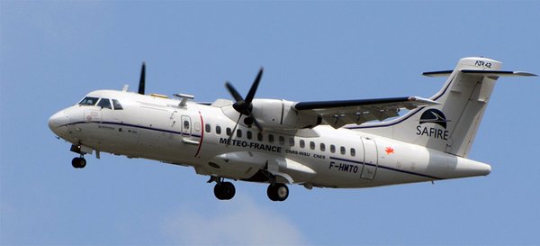
The French ATR-42 ( schematic) is a bi turbo-prop aircraft from SAFIRE that has the capability of flying in the lower troposphere (ceiling at about 8 km) with a maximum range of about 1800 km. It will fly a series of low-level legs either within the sub-cloud layer, and within the cloud layer, especially just above cloud base (around 1 km). The legs will be about 100 km long and spaced by about 20 km, and will sample the cloud field within the area encompassed by HALO circles. A particularity of the aircraft instrumentation is that it will include sideways and vertical-pointing lidar and radars that will probe the atmosphere horizontally and vertically, aiming at measuring the cloud fraction at cloud base. The legs below cloud level will aim at characterizing turbulence structures within the subcloud-layer, both cross-wind and along-wing, the thermodynamic properties of the subcloud-layer, temperature at the sea surface, and radiative fluxes. Given the mean science speed of the aircraft (about 100 m/s) and the endurance expected for the envisioned payload, the ATR-42 will make two four-hour flights per day bracketed by the daily nine-hour flight of HALO.
Instrumentation
| Thermodynamics and turbulence: | Temperature, pressure and wind will be measured at high frequency. Humidity will be measured both by a Licor-7500 sensor (2-3 Hz) and by two KH-20 sensors (10 Hz). These measurements will make it possible to characterize the turbulent structure of the subcloud-layer. (SAFIRE, CNRM/TRAMM, PI: Marie Lothon, LA ) |
|---|---|
| Microphysics: | The aerosol and droplet size distributions will be characterized by UHSAS (60 nm to 1μm), FSSP 300 (0.3 to 20 μm), CDP/FCDP (2-50 μm) and 2D-S (10-1280 μm) measurement probes. The total and liquid water content will be directly measured by two instruments (a Nevzorov for the total water content and a LWC300), and indirectly calculated from droplet size distributions. (SAFIRE, CNRM/TRAMM, PI: Alfons Schwarzenboeck, LAMP) |
| RASTA Radar: | Upward and downward looking 95 GHz Doppler pulsed cloud radar with four antennas (three above the aircraft and one below the aircraft) for the characterization of cloud microphysics and dynamics. The system allows us to retrieve the 3D wind above the aircraft, to detect updrafts, downdrafts and the presence of precipitation. (PI: Julien Delanoë, LATMOS) |
| BASTA Radar: | Side looking bistatic FMCW 95 GHz Doppler cloud radar will derive the cloud fraction at the altitude of the aircraft and (depending on flight plans) the vertical cloud mask. Additional cloud properties will be retrieved, such as liquid water content. BASTA and AliAS will team up to make the most of the radar-lidar synergy, combining the high sensitivity of the lidar and the capability of penetrating optically thick clouds of the radar (lidar more sensitive to the concentration of the hydrometeors and radar to the particle size). (PI: Julien Delanoë, LATMOS) |
| AliAS Lidar: | Lightweight eye-safe backscatter lidar operating at 355 nm and detecting parallel and perpendicular polarization. The system will be deployed in sidewards looking mode to monitor the aerosol and hydrometeor distributions and dispersions in the lower troposphere with an along the line of sight resolution of 30 m and full overlap beyond 200 m. AliAS will allow detecting clouds up to 10 km. The across line of sight resolution will depend on the sampling strategy. (PI: Patrick Chazette, LSCE) |
| CLIMAT CE332: | Three channel downward staring measurements of infrared irradiance at 8.7, 10.8, and 12.0 μm to measure sea-surface temperature. (SAFIRE, CNRM/TRAMM, PI: Gérard Brogniez, LOA) |
| Pyrgeometer and Pyranometer: | Hemispheric broadband upwelling and downwelling longwav (4.5 µm– 42 µm) and shortwave (200 nm – 3600 nm) radiative fluxes. (SAFIRE, CNRM/TRAMM, PI: Gérard Brogniez, LOA) |
| Camera VIS | A high-resolution VIS-camera (Prosilica GT 1930) VIS-camera installed and looking through one of the aircraft window, next to the horizontally-looking lidar and radar. This camera will be used to characterize the environment of lidar/radar measurements, and to reconstruct the vertical structure of the cloud side surface by stereography. (PI: Céline Cornet, LOA) |
| Picarro: | Cavity Ring-down laser spectrometric measurements of the stable water isotopic composition will made on-board the aircraft using a custom-made flight Picarro L2130. It will measure the isotopic ratios of Oxygen-18 and Deuterium. (PI: Aemisegger Franziska, ETH) |
PI/Contact:
Sandrine Bony (LMD), Julien Delanoë (LATMOS) and Cyrille Flamant (LATMOS)
References
AliAS: Chazette P (2016) Exceptional aerosol pollution plume observed using a new ULA-lidar approach. Atmosph Environ 141:470–480. doi:10.1016/j.atmosenv.2016.07.015
BASTA: Delanoe ̈J, Protat A, Vinson JP, Brett W, Caudoux C, Bertrand F, du Chatelet JP, Hallali R, Barthes L,Haeffelin M, Dupont JC (2016) Basta: a 95-GHz FMCW Doppler radar for cloud and fog studies.J Atmos Ocean Technol 33(5):1023–1038. doi:10.1175/JTECH-D-15-0104.1
CLIMAT: Brogniez G, Pietras C, Legrand M, Dubuisson P, Haeffelin M (2003) A high-accuracy multiwavelengthradiometer for in situ measurements in the thermal infrared. Part II: behavior in field experiments.J Atmos Ocean Technol 20(7):1023–1033. doi:10.1175/1520-0426(2003)20\1023:AHMRFI[2.0.CO;2]
Picarro: Aemisegger F., Sturm P., Graf P., Sodemann H., Pfahl S., Knohl A. and Wernli H., 2012. Measuring variations of δ18O and δ2H in atmospheric water vapour using two commercial laser-based spectrometers: an instrument characterisation study. Atmos. Meas. Tech. 5, 1491-1511,  doi:10.5194/amt-5-1491-2012.Sodemann H., Aemisegger F., Pfahl S., Bitter M., Corsmeier U., Feuerle T., Graf P., Hankers R., Hsiao G., Schulz H., Wieser A., and Wernli H., 2017. The stable isotopic composition of water vapour above Corsica during the HyMeX SOP1 campaign: insight into vertical mixing processes from lower-tropospheric survey flights. Atmos. Chem. Phys. 17, 6125-6151, doi:10.5194/acp-17-6125-2017.
Pyranometer and Pyrgeometer: Kipp and Zonen CMP22 and Kipp and Zonen CGR4
RASTA: Delanoë J, Protat A, Jourdan O, Pelon J, Papazzoni M, Dupuy R, Gayet JF, Jouan C (2013) Comparison of airborne in situ, airborne radar–lidar, and spaceborne radar-lidar retrievals of polar ice cloud properties sampled during the Polarcat campaign. J Atmos Ocean Technol 30(1):57–73. doi:10.1175/JTECH-D-11-00200.1