Simulations
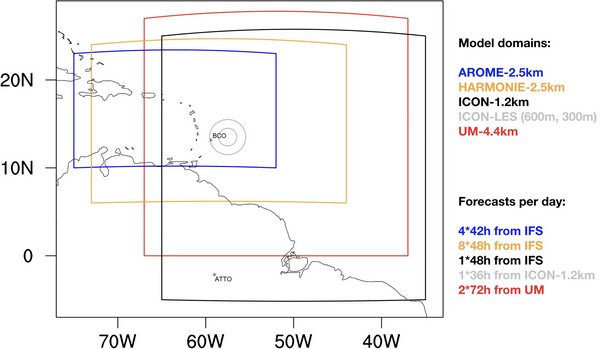
An exciting component of EUREC4A will be the multi-scale modelling in connection with the field campaign. Global climate models to idealized large-eddy models will be used to help address the questions at the heart of EUREC4A and to learn from measurments. Global and regional weather forecast models will be used for flight operations and retrospective simulations will be performed with focused configurations to address specific research questions. The operational weather forecasts with storm-resolving models for the EUREC4A area with AROME (MeteoFrance) and HARMONIE (KNMI) will be complemented by storm resolving weather forecasts with ICON (DWD) and UM (UK MetOffice). Targeted large-eddy simulations are planned and several projects and initiatives aligne their modeling activities with the EUREC4A field experiment. An overview will be given here soon.
As an example, below are shown simulations performed in support of NARVAL2. These were perfomred through the DWD sponsored HErZ cooperation with MPI-M, 2.5 km storm-resolving simulations were being performed over the entire tropical Atlantic. These simulations included a 1.25 km nest over the western Atlantic and a yet finer (300 m) simulation nest over the area of flight operations. A prototype simulation, showing the wind field is illustrated in the animated gif below. During EUREC4A we anticipate being able to perform 300 m resolution simulations over the entire domain with finer (50-100 m) nested simulations over the flight area. ( DKRZ cloud storage system)

The animation shows convection resolving ICON simulations over the tropical Atlantic accompanying the NARVAL campaigns (by Daniel Klocke, DWD and Matthias Brueck, MPI-M). Emergent phenomena are featured in unprecedented detail, ranging from cold-pools of small cumuli, interacting squall lines of deep convection to hurricanes evolving from breaking easterly waves. Over 40 days are already simulated within the period of NARVAL-I (Dec 2013) and NARVAL-II (Aug 2016). The model resolution is 2.5 km with a nested domain of 1.2 km over the western part of the domain. These results are further used as input to large-eddy simulations with ICON within the HD(CP)2 project.
PIs/Contact:
- Daniel Klocke - Deutscher Wetterdienst
- Vera Schemann - University of Cologne
- Pier Siebesma - Delft University of Technology