Boréal UAV
Developed by BORÉAL SAS, the Boréal unmanned aerial vehicle (UAV) is a fixed-wing platform, weighing less than 25kg and capable of traveling 700 km with a payload of 5 kg. The Boreal has a wingspan of 4.20 meters and has a nominal cruise speed of 100 km h-1 (with a range between 60-130km h-1). The BOREAL is particularly well-suited for probing the marine boundary layer between 40 and 3000 m.asl. The BOREAL system has been used successfully by the Centre National de Recherches Météorologiques (CNRM) of Metéo-France during the MIRIAD and RENOVRISK campaigns in the Indian Ocean. The Boréal UAV will make one six-hour flight per flight day coordinating with the other research aircraft (HALO, ATR-42 and the Twin Otter).
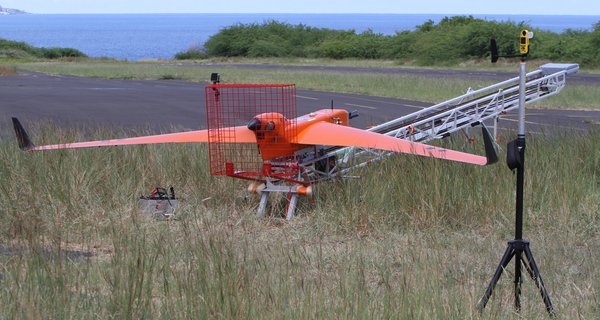
The Boréal UAV is launched from a catapult (see picture) and lands on its belly allowing for relatively short take-off and landing operations in the field. It is equipped with a transponder (24-bit S-mode) for integrating flights into international airspace, a radio frequency / satellite communication system for long distance flight. The payload of 5 kg includes sensors to measure air-sea exchanges: multi-hole 3D wind and turbulence probe, particle counter and number size distribution, altimetry radar (wave height), temperature of sea surface, downwelling broadband solar radiation, pressure / temperature / humidity and real-time video. Data from these sensors are available in real-time on the ground station.
Instruments:
| Condensation particle counter | The condensation particle counter measures total aerosol concentrations (NCN) between 0 and 105 cm-3 in the diameter range (dp > 0.01 µm. The condensation particle counter is used to identify new particle formation and pollution aerosol. |
| Optical particle counter | An optical particle counter measures aerosol size distributions (0.3 µm < dp < 3 µm) to measure emissions of primary marine aerosol and confirm mixing in the boundary layer. |
| Multi-hole turbulence probe | The multi-hole turbulence probe extends into the free stream in front of the UAS to measure the three-dimensional wind vectors, boundary layer turbulence and fluxes. |
| Sea surface temperature | The infrared sensor measures sea surface temperature during low altitude legs (< 100 m.asl). |
| Radar altimeter | The radar altimeter is used to measure sea state including wave height, speed and direction. The different types of waves (e.g., swell and wind can also be distinguished). |
| Broadband solar irradiance | The pyranometer measures total hemispherical solar irradiance over spectral range between 0.4 µm and 01.1 µm. The pyranometer will be used to detect clear sky and cloud coverage. |
| State Parameters | These sensors are used to measure temperature, pressure and relative humidity, from which atmospheric parameters including potential temperature, stability, boundary layer height, and lifting condensation level are derived. |
PI/Contact:
Greg Roberts (greg.roberts@meteo.fr)
CNRM/SIO
Michel Gavart (michel.gavart@boreal-uas.com)
Boréal SAS
Sebastien Barrau (sebastien.barrau@meteo.fr)
CNRM
References:
Corrigan, C.E., G.C. Roberts, M.V. Ramana, D. Kim, and V. Ramanathan: Capturing Vertical Profiles of Aerosols and Black Carbon over the Indian Ocean using Autonomous Unmanned Aerial Vehicles, Atmos Chem Phys, 8, 737-747, 2008.
Roberts, G.C., M.V. Ramana, C. Corrigan, D. Kim, and V. Ramanathan: Simultaneous observations of aerosol-cloud-albedo interactions with three stacked unmanned aerial vehicles, PNAS, 105, 7370-7375, 2008.
Sanchez, K.J., G.C. Roberts, R. Calmer, K. Nicoll, E. Hashimshoni, D. Rosenfeld, J. Ovadnevaite, J. Preissler, D. Ceburnis, C. O'Dowd, L.M. Russell, Top-down and bottom-up aerosol–cloud closure: towards understanding sources of uncertainty in deriving cloud shortwave radiative flux, doi.org/10.5194/acp-17-9797-2017, 2017.
Calmer, R., G.C. Roberts, J. Preissler, K.J. Sanchez, S. Derrien, C. O'Dowd, Vertical wind velocity measurements using a five-hole probe with remotely piloted aircraft to study aerosol–cloud interactions, doi.org/10.5194/amt-11-2583-2018, 2018.
Calmer, R., G.C. Roberts, K.J. Sanchez, J. Sciare, K. Sellegri, D. Picard, M. Vrekoussis, M. Pikridas, Aerosol-Cloud Closure Study on Cloud Optical Properties using Remotely Piloted Aircraft Measurements during a BACCHUS Field Campaign in Cyprus, doi.org/10.5194/acp-2019-8, 2019.