The Barbados Cloud Observatory (BCO)
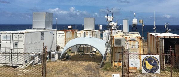
The Barbados Cloud Observatory (BCO) is largely defined by a cluster of instruments at Ragged Point, a promontory on the windward coast of Barbados. This location is well situated to observe the air masses carried by the trade winds over the Atlantic Ocean. During EUREC4A the site will be augmented by measurements made at Ragged Point, just across a small cove, and from an elevated location hosting the PoldiRad radar, a few kilometers away. The measurement station at Ragged Point has been in operation since April 1, 2010, and is equipped with standard meteorological instruments (measuring e.g. temperature, humidity, pressure, wind, rain rate, solar irradiance) and several remote sensing instruments to study the vertical distribution of overpassing clouds, aerosols and water vapor as a function of the large-scale environment. For the EUREC4A campaign, the BCO provides the long-term context for intensive observations, which will be combined with measurements from other platforms to achieve the campaign objectives. (photo credit: Sabrina Schnitt)
Instrumentation:
| Raman Lidar: | The upward looking multichannel Raman lidar uses a neodymium-doped yttrium aluminium garnet (Nd:YAG) 10-Hz laser with three wavelengths (355 nm, 532 nm and 1064 nm) to profile clouds and aerosol properties and to retrieve temperature and humidity profiles. The current Raman lidar is running since May 2019. Data from former Raman lidar instruments are available since April 2010. |
| Ka-band Cloud Radar: | Upward looking polarized Doppler cloud radar to detect radar reflectivity, Doppler velocity and linear depolarization ratio of cloud particles. The radar is operating with a frequency of 35 GHz and has a sensitivity of -48 dBZ at an altitude of 5 km and -70 dBZ at an altitude of 500 m. It measures a vertical range between 150 m and 18.9 km with a vertical resolution of 30 m. The Doppler resolution is < 0.02 ms-1 between -10 ms-1 and 10 ms-1. Data are available since April 2015 with a temporal resolution of 10 s (2 s since July 2018). Data from a former radar with similar characteristics but a lower sensitivity are available since December 2010. |
| W-band Cloud Radar: | Upward looking polarized Doppler 94 GHz cloud radar to detect radar reflectivity, Doppler velocity and linear depolarization ratio of cloud particles. The W-Band radar is measuring since December 2018 at altitudes between 150 m and 15 km with a temporal resolution of 2 s. |
| Two Doppler Wind Lidar: | One upward looking (since July 2015) and another horizontal scanning Doppler lidar (since February 2019) to measure vertical and horizontal wind speed. Both instruments use a laser beam with a wavelength of 1500 nm to measure at an altitude between 50 m and ~1000 m. The temporal resolution of the vertical wind speed is 1.3 s. Horizontal wind speed and direction are averaged over an interval of 2 minutes. |
| Microwave Radiometer: | Humidity and temperature profiling radiometer (HATPRO). Two bands, 22 - 31 GHz and 51 - 58 GHz. The vertical resolution is less than 40 m in the sub-cloud layer with a temporal resolution of ~1 minute. Data from the current microwave radiometer are available since April 2017. Data from a former microwave radiometer are available since January 2011. |
| Micro-Rain-Radar: | Upward looking 24 GHz Micro-Rain-Radar to detect fall velocity of hydrometeors and rain rate. Both parameters are measured at an altitude between 100 m and 3 km with a temporal resolution of 1 Minute. Data are available since April 2010. |
| Ceilometer: | The Ceilometer is using a non-visible laser beam with a wavelength of 1064 nm to detect the cloud base height up to ~10 km. It is running since 2010 with a temporal resolution of 10 s. |
| Radiation: | Pyranometer, Pyrgeometer and Pyrheliometer for radiance and irradiance measurements. The temporal resolution is 1 s and the instruments are running since April 2015. |
| Weathersensor: | Two meters above ground, several sensors measuring pressure, temperature, humidity, precipitation, wind speed and wind direction since December 2010 with a temporal resolution of 10 s. |
| Disdrometer: | Detects drop size distribution and velocity of falling hydrometeors. Data are available since May 2017. |
| Allsky-Imager: | The Allsky-Imager uses a fish-eye objective to take a picture every minute of the entire sky. The center part of the picture is also covered by an IR-Camera, which detects the temperature at the cloud base. Pictures of the Allsky-Imager are available since 2010. The thermal camera has taken pictures since the end of 2018. |
| Webcam Movies: | A camera located at Ragged Point faces towards the easterlies and shows the daily weather situation in the vicinity of the Barbados Cloud Observatory. The daily movies are available since February 2010. |
| PoldiRad | During EUREC4A the capabilities of the BCO are enhanced by the deployment of the Polarization-Doppler-Radar POLDIRAD of the Germany Aerospace Center (DLR) on a mountain ridge northwest of the BCO. POLDIRAD is a horizontal scanning 5.5 GHz radar with a maximum range of 300 km. It will be used to measure e.g. Reflectivity, Doppler velocity and Depolarization ratio of cloud droplets. The instrument is operating on Barbados from Fall 2019 to Spring 2020. |
| CCN & Aerosol | These measurements are being provided by Mira Pölker of the Max Planck Institute for Chemistry in Mainz, and details of the planned measurements will be made available soon. |
References:
Stevens, B., et al., (2016). The Barbados Cloud Observatory — anchoring investigations of clouds and circulation on the edge of the ITCZ. Bulletin of the American Meteorological Society, 97, 787-801 ,  doi:10.1175/BAMS-D-14-00247.1
Contact:
- Marvin Forde (Caribbean Institute for Meteorology and Hydrology)
- Friedhelm Jansen (Max Plank Institute for Meteorologyy)
Instrument Team:
Brügmann, Serikov, Jansen (MPI-Met), Mech, Schnitt (UKöln), Forde (CIMH)