NTAS (Northwest Tropical Atlantic Station)
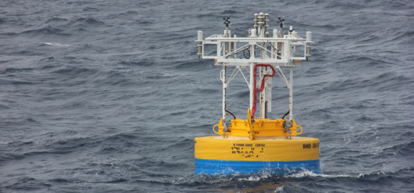
The Woods Hole Oceanographic Institution (WHOI) has maintained the NTAS open ocean surface mooring with support from the US National Oceanic and Atmospheric Administration (NOAA) since March 2001. NTAS is located near (51ºW, 15ºN), which is roughly 900 km east of the  BCO and will be the easternmost point ofthe
  ATOMIC leg 1 cruise of the R/V Ronald H. Brown in January 2020. The NTAS mooring is recovered and replaced yearly to provide a near contiguous record with regularly calibrated instrumentation. The basic dataset collected at NTAS consists of near-surface meteorology from the buoy and oceanic variables (temperature, salinity, currents) at discrete depths in the upper 200 m or more of the ocean. The Air-Sea Interaction METeorology (ASIMET) system collects air temperature and humidity, wind, barometric pressure, and radiation budget at about 3 m above sea level, as well as sea surface temperature and salinity at about 1 m depth. These observations are routinely combined to compute turbulent air-sea fluxes of momentum, heat and freshwater. NTAS data have a high resolution in time (up to 1-minute) and vertical (up to 5 m). These attributes and the well-documented state-of-the-art accuracy of ASIMET render the NTAS data a unique record. The NTAS platform is well suited for air-sea interaction studies, and is available for auxiliary science projects. In the recent years, waves measurements have for example been added to the basic data set. Telemetered data also offers opportunities for operational purposes, calibration/validation of remote sensing instruments, and model assimilation.
Instrumentation:
All the ASIMET electronics are located inside a housing that is fouling and corrosion resistant (titanium) and immersion tolerant (o-ring seals). ASIMET data is hourly averaged before sending through Iridium telemetry. Internal memory contains the full 1-minute record. A portion of the upper 70 m of hourly ocean data is also telemetered
| Air Temperature & Humidity | A Rotronic MP-101A measures air temperature (ºC) and relative humidity (%RH). The sensor probe is protected by a Rotronic MF25 membrane filter and placed inside a modified R.M. Young multi-plate radiation shield to minimize corrosion from sea spray and solar heating. |
| Wind | An R.M. Young 510 vane and propeller wind sensor, integrated with compass to provide wind direction (degrees) and speed (m s-1). Wind vector estimates are computed every 5 seconds and averaged together to produce one data record each minute. Propeller bearings are replaced after one year of field operations. The wind sensors are mounted high and forward on the buoy to minimize flow disturbance created by the mounting platform. A large vane is mounted on the buoy itself to steer it into the wind. |
| Shorwave Irradiance | An Eppley Precision Spectral Pyranometer (PSP) provides total downwelling shortwave radiation (W m-2). Sensor has 1-second response time and is sampled 11 times during each minute to provide a one-minute average. Sensor uses a temperature-compensated thermopile and is mounted on an aluminum base which provides a reference mass, and the base is mounted to a PVC endcap for thermal isolation from the housing. Domes made of clear glass which is transparent to energy between 0.285 to 2.8µm. Domes are susceptible to fouling by salt particles, dust, and guano. The sensor is mounted high on the buoy to avoid shadowing of the dome for all sun angles. |
| Longwave Irradiance | An Eppley Precision Infrared Radiometer (PIR)Provides total downwelling longwave radiation. The sensor measures dome temperature (K), body temperature (K), thermopile voltage (V) and longwave radiation flux (W m-2). Sensor has 2 s response time and is sampled once per minute. Isolation of long-wave radiation in daytime is accomplished by using a silicone dome and filter with a transmission range of approximately 3.5 to 50 µm. Domes are susceptible to fouling by salt particles, dust, and guano. The sensor is mounted high on the buoy to avoid shadowing of the dome for all sun angles. |
| Air pressure | An Heise DXD provides barometric pressure (hPa). A parallel-plate pressure port is used to reduce dynamic pressure errors (due to wind blowing over an exposed sensor port) to < 0.5 hPa at 20 ms-1. An internal baffle system impedes water and snow intrusion. |
| Rain | An R. M. Young 50202 self-siphoning rain gauge provides water level (mm). The sensor housing is susceptible to cracking if the column of water inside freezes. Rain rate must be computed by post-processing, accounting for the occurrence of siphoning intervals. Drainage time is approximately 20 sec. Catchment intake is susceptible to fouling by guano. |
| Meteorology | Vaisala WXT520 weather station mounted as a standalone unit (not ASIMET). Measures barometric pressure, sonic wind speed, air temperature and relative humidity and rain. |
| Waves | A WAMDAS measures wave parameters. Data is sent to and processed by National Data Buoy Center (NDBC station 41060). Not all deployments include WAMDAS measurements. |
| Seawater temperature and salinity | Seabird 37 (Microcat) provides seawater temperature (ºC), conductivity (S m-1) and pressure (dbar), from which salinity (psu) is derived. Data if sampled every 5 min (1-min for SST and SSS from near surface sensor integrated into ASIMET). |
| Seawater temperature | Seabird 39, Starmon Oddi provide seawater temperature (ºC) every 5 minutes |
| Currents 1 | RDI Acoustic Doppler Current Profiler, 300 kHz provides hourly ocean current speed and direction in 4 m vertical bins from surface to 80 m depth. |
| Currents 2 | Nortek Acoustic Doppler Current Profiler, 600 kHz Provides hourly ocean current speed and direction in 2 m vertical bins from surface to 23 m depth. |
| Currents 3 | Nortek Acoustic Doppler Current Meters provide ocean current speed and direction every 20 minutes at 6m and 13 m depths. |
Contact:
Sebastien Bigorre (sbigorre@whoi.edu)
Woods Hole Oceanographic Institution
PI
Al Plueddemann (aplueddemann@whoi.edu)
Woods Hole Oceanographic Institution.