4 Feb
I realize I am a bit behind but I would like to share some thoughts on the day before yesterday, 4th February.
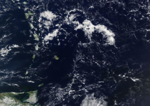
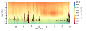
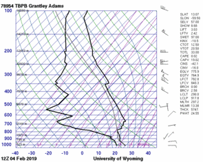
Looking at MODIS Terra (overpass 14:30 UCT) it caught my eye how our beloved Barbados is located in a cloud hole (150 km x 300 km) while some cold pool gravel clouds with much finer structures approach from further upstream (Fig. 1). At BCO we see the clear sky region passing by between 13:00 and 18:30 UTC (well, except some tiny cloud speckle around 16) along with a clear minimum in relative humidity around 2 km (Fig. 2, credit and thanks to Hauke). Before 13:00 and after 18:30 the humidity is higher that day and clouds appear. Some of them even precipitate as we might expect from cold pools. At 12 UTC the sounding not surprisingly shows trade winds from the east near the surface but some reversal to southwest right at the height where the moisture gradient is high (Fig. 3). Is this the imprint of a secondary shallow circulation on top of the trade wind flow?
How do these moisture and cloud structures (or should I rather say clear-sky structures?) interact with low-level circulations on scales of few hundreds of kilometers?
While the paradigm of shallow circulations has often been to associate them with SST differences or with a land-sea breeze, I would like to use the opportunity and make a plea for another mechanism, which could be at play: radiatively driven circulations.
In subsidence regions with a dry free-troposphere and a moist boundary layer, low-level radiative cooling is strong because the moist and warm boundary layer strongly emits longwave radiation but relatively little returns from the dry layer above. For a weaker humidity inversion due to moister air above the BL, the radiative low-level cooling is considerably weaker. The magnitude of differences in low-level radiative cooling can easily reach 3-5 K/day on a spatial scale of maybe 200 km. This differential low-level radiative cooling affects the low-level temperature structure, which in turn can cause a pressure driven flow. Using a conceptual (bulk layer) model, Bjorn, Cathy and myself argue that a shallow circulation, which is driven by and dynamically couples two areas with different radiative low-level cooling, significantly modifies the boundary layer balance and its properties. In particular, the shallow circulation is able to suppress convection in areas with stronger low-level radiative cooling and enhance convection with weaker low-level radiative cooling. One might hypothesize that this mechanism resembles patterns of shallow organization with convecting and non-convecting areas in close vicinity to each other, maybe such as the dry region around Barbados two days ago? Here shallow organization is as much marked by its cloud-free as by its cloudy properties.
I hope EUREC4A will allow us to probe cloudy and cloud-free regions and test these mechanisms in the field.
In yesterdays post, Raphaela gave us a nice introduction about the shallow convective mass flux and how it will be measured during the EUREC4A campaign. But did you ever wonder if we are able to measure the shallow convective mass flux directly from a ground station? And if we are able to measure it, what does a vertical mass flux profile look like? I am currently working on this topic, and in today’s post, I would like to explain to you how we can use our remote sensing instruments at the Barbados Cloud Observatory (BCO) to measure the shallow convective mass flux.
First of all, what do we need for our recipe to calculate the mass flux? Based on the definition by Arakawa and Schubert (1974) the shallow convective mass flux, m, is the product of the air density, ρ, the fraction of area covered by updrafts, a, and the vertical velocity, ω, averaged across all updrafts. To keep it simple, we assume that the air density is constant with 1.2 kg/m3. The vertical velocity of the cloud particles can be retrieved by Doppler radar measurements. Ghate et al. (2011) and Lamer et al. (2015) have done this and instead of calculating the fraction of area covered by updrafts for every single cloud, they used the cloud fraction over a specific time period (e.g. 1h).
We do the same in our approach, and because we additionally want to know how the mass flux profile looks below the cloud base, we are using Doppler lidar measurements to get the vertical velocity in the sub-cloud layer. The following figure shows Doppler radar and Doppler lidar measurements at the BCO from Pre-EUREC4A day 2.  The upper panel shows a cloud mask (I like to call it the Konow-cloud mask, because Heike Konow developed it), which labels every cloud as a number with associated parameters, like cloud base and cloud top height. Because we are only interested in the mass flux from shallow c
umulus clouds, we are removing all clouds with a cloud base lower than 300 m (precipitating clouds) and higher than 1 km. The result is shown in the center panel, which we are using to calculate the cloud fraction. The panel at the bottom combines the measurements from both the Doppler radar and the Doppler lidar instrument and shows the vertical velocity from near the ground to the cloud top for every single cloud.
 In the next figure, we see the averaged shallow convective mass flux profile from this day in the right panel, which is the product of the air density, cloud fraction (left panel) and vertical velocity (center panel). First, we take a look at the mass flux profile below the cloud base height. Because we define the cloud fraction below cloud base as constant, the variation of the mass flux is only controlled by the vertical wind speed. Its maximum is in the center of the sub-cloud layer (~250 m), which is plausible because the borders of the mixed boundary layer (ground and cloud base) act as barriers, where the vertical windspeed is expected to be close to zero.
The mass flux profile above cloud base shows a strong increase with increasing altitude up to ~750 m, which is caused by latent heat of condensation. It means that as soon cloud droplets are forming, the release of latent heat warms the surrounding air, which reinforces the upward motion.
All in all, I hope I could give you a rough idea how we can use ground based remote sensing instruments to measure the tropical shallow convective mass flux. I will use this method to investigate further questions, like „How does the mass flux vary during the day and during the year?“ and „How does the different development status of clouds affect the mass flux profiles?“. In case you are interested in more details and you are participating at the UCP 2019 in Berlin, please take a look at my poster:
Poster Session A, Track 2: Measuring the shallow convective mass flux
References:
Arakawa, A and W. H. Schubert (1974): Interaction of a cumulus cloud ensemble with the large-scale environment, Part I, J. Atmos. Sci. 31, 674–701.
Ghate, V. P., M. A. Miller, and L. DiPretore (2011): Vertical velocity structure of marine boundary layer trade wind cumulus clouds, J. Geophys. Res., 116, D16206, doi:10.1029/2010JD015344.
Lamer, K., P. Kollias, and L. Nuijens (2015): Observations of the variability of shallow trade wind cumulus cloudiness and mass flux, J. Geophys. Res. Atmos., 120, 6161–6178, doi:10.1002/ 2014JD022950.


