Research Vessel Ronald H. Brown
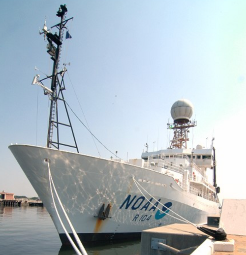
As part of ATOMIC, NOAA's R/V Ronald H Brown will be deployed during EUREC4A between 6 January and 13 February. The R/V Ronald H. Brown will focus on air-sea interaction with an emphasis on the mesoscale, primarily operating in the area between the R/V Meteor (upwind of Barbados) and the NTAS buoy near 51 ºW. Presently it is scheduled to leave Barbados on 6 January for its first leg, initially heading to the NTAS buoy region. During the transit to NTAS, 2 wavegliders and 6 SWIFTS will be deployed. Brown will spend ~ 6 days in the vicinity of the NTAS buoy to replace the buoy; make upwind in situ and remote measurements of boundary layer, aerosol, and cloud properties; and conduct UAV flights. Once buoy operations are complete, Brown will work further west in the Tradewind Alley upwind of EUREC4A platforms and in coordination with the NOAA WP-3D. On Jan. 24, Brown will pick up SWIFTS and transit to ~20 nm upwind of BCO for an inter-comparison with the observatory and other platforms in the area. Brown will return to Bridgetown on Jan. 26 for a brief inport and open house. Leg 2 will begin on 28 January and will focus on measurements in a region mid-way between the HALO circle and NTAS thus serving as an upwind point of observation for the EUREC4A campaign. The R/V Ronald H. Brown will conclude its mission upon returning to Barbados on 13 February.
Instrumentation:
| Microwave radiometer | For the measurement of integrated water vapor and liquid water path (PIs: Zuidema/Fairall) |
| M-AERI | IR sea surface skin temperature (PIs: Minnett/Zuidema) |
| Disdrometers | Two disdrometers will measure the size, fall speed, and precipitation intensity of the different types of precipiation encountered (PI: Zuidema) |
| Camera | All sky visible camera |
| Radiosondes | Soundings will be conducted 4 times per day. The Vaisala RS41 radiosondes will provide high-resolution temperature, RH, P, and wind profiles up to the 50 - 100 mb level (PI: deSzoeke) |
| Stable Water Isotopologues | Continuous measurements of H2O, δD, δ180 water vapor and discrete sea water and precipitation samples from a Picarro gas analyzer (PI:Noone) |
| SWIFTS (IFT drifters) | Six SWIFTS will be deployed and recovered every few days. All models will have bulk winds, air temperature, RH, pressure and ocean surface currents at 0.3 meters. The v3 models will measure ocean turbulence in the upper 0.5 meters. The v4s will measure ocean turbulence in the upper 2 meters along with ADCP profiles of currents down to 20 meters (Pis: Thompson/Thomson) |
| Wavegliders | Two wavegliders will be equipped with bulk winds, air temperature, RH, pressure, long wave and short wave radiation, sky cameras, wave motion sensors, downlooking ADCPs, and ocean currents at 0.3 and 8 meters depth (Pis: Thompson/Thomson) |
| Doppler lidar | NOAA CSD's doppler lidar for the measurement of atmospheric velocities and backscatter. The measurements yield information about boundary layer turbulence (PI: Brewer) |
| Air-sea flux system | Flux system consists of Licor fast humidity, motion system, optical rainguage, lidar wave gauge, mean T/RH/pressure sensors, GPS heading (PI: Fairall) |
| Broadband radiometers | Surface radiation (LW & SW) irradiances |
| Sea Snake | Sea surface temperature (PI: Fairall) |
| Unmanned aerosol systems (UAS) | Vertical profiling will be conducted with 3 different payloads for one flight per payload per day. The Clear Sky payload measures aerosol size distribution, total number concentration and composition and aerosol optical depth (PIs: Quinn/Bates). The Cloudy Sky payload measures aerosol size distribution, total number, and cloud drop number concentration (PIs: Quinn/Bates). The mini-Flux payload measures atmospheric thermodynamic state, turbulence, 3D winds, and surface and sky IR temperature (PI: de Boer). |
| Underway CTD | For the measurement of surface water conductivity and temperature while the ship is underway (PI: Bigorre) |
| Thermosalinograph | Underway sensor package to sample near surface temperature and salinity (Ship) |
| Cloud Radar | NOAA PSD's W-band radar (95 GHz) for the measurement of the extent and composition of clouds (PI: Fairall) |
| Ceilometer | Cloud-base fraction as a function of altitude and backscatter (PI: Fairall) |
| Sun photometer | Hand held microtops sunphotometer for the measurement of aerosol optical depth (PI:Quinn) |
| In situ aerosol instrumentation | Aerosol number concentration, size distribution, chemical composition, volatility at 230C, light scattering and backscattering at 3 wavelengths, light absorption at 3 wavelengths, f(RH) for scattering, and cloud condensation nuclei concentration (PIs: Quinn/Bates). |
PI/Contact:
Patricia (Trish) Quinn, NOAA Applied Physics Laboratory, Seattle Washington. All general questions should be directed to her. For instrument specific questions, contact the instrument PIs identified above.

