Set Up : Storm Resolving Models.
Domain, Period and Resolution
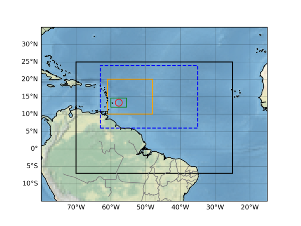
We want to keep the set up as simple as possible as to make it easy for modelers to participate to this EUREC4A-MIP. Therefore the only requirement we impose is that the domain size should contain at least a common analysis domain spanning 10 N to 20 N and 48 W to 61 W (see orange dashed box in Figure 1). The actual used modeling domain should be substantially larger and preferable be extended to the upstream Eastern direction. Ideally the domain should include the equator and extend from 5 S to 25 N and 25 W to 70 W. However also smaller domains as indicated by the dashed blue box are also acceptable.
The horizontal resolutions should be in the range of 0.5 to 2.5 km. Multiple submissions with a high (0.5~1 km) and a lower resolution are encouraged. No specific vertical resolution is prescribed because many SRM’s use their own preferred variable vertical resolution. However we encourage to use vertical resolutions of around 20 meter near the surface, and around 100 meter in the cloud layer between 1000 and 2000 m height
The simulation period is from 0 UTC on January 1st 2020 to 0 UTC on March 1st 2020.
Initial and Lateral Boundary Conditions for Present Day Simulations
The simulations of the present day Limited-area Models (LAMs) run from 01-01-2020, 0 UTC to 01-03-2020 0 UTC with hourly prescribed Sea Surface Temperatures (SST) and Lateral Boundary Fields. We strongly encourage participants to use ERA5 reanalysis data for both the initialisation of the simulations as well as for the lateral and surface conditions. To facilitate this we have made hourly 3d fields from ERA5 available on a domain of 5S to 25N and 25W to 70W as well as the relevant 2D surface fields for the whole 2 months simulation period. All the relevant ERA5 data needed for the initialisation, the lateral boundary fields and the surface fields are available in a netcdf format on a hourly basis and can be obtained here.
Initial and Lateral Boundary Conditions for Future Weather Simulations
For the Future Weather runs, the SST fields are increased by 4K and the lateral ERA5 boundary fields are perturbed with perturbation fields that are derived from a 30 year monthly means difference between a +4K-SST and a present day global climate simulation (see also section on methodology and references there for further details). For this purpose output data of the GFDL model has been used, a model with a moderate equilibrium climate sensitivity (ECS).
The PGW perturbations have already been added to the ERA5 fields and the plus 4K perturbtaion have also all been added to the SST fields. So in order to simulate this Future Weather Simulation, just use exactly the same set-up as for the Present Day Simulation using the hourly initialisation and perturbed boundary ERA5 fields that can be found HERE.
Required Output
The required output fields and fluxes are described HERE. Submit 2 data sets: one for the present day case and one for the future weather case.
The data for EUREC4A-MIP should be uploaded in the Zarr format. One way to create the zarr data is to save data from the model in netCDF and then convert it to zarr when uploading. Zarr has a similar data model to netCDF, so metadata like units and attributes are preserved when converting. See HowtoEUREC4A for detailed instructions on the format and upload procedure.