29 Jan
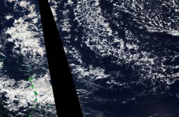
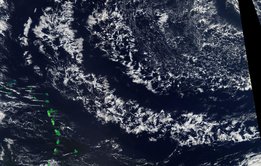
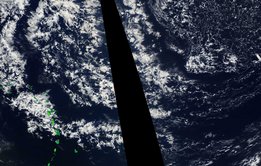
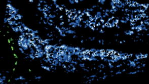
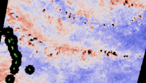
Sandrine and Hauke’s talk of flowers and fish have had me looking more at worldview the past days. What has been interesting is a very large-scale pattern of banded features (remember the roll wave discussions) that are pushing down from the NorthEast. Basically I see arc like bands of clouds, which have an open-cell network-like pattern (looked at closely they could be mistaken for the skeletal structures we associated with fish), delineated by an unusually large cloud\-free regions. So today over Barbados there is really an amazing poverty of clouds, and (as is usual in such a situation) low wind speeds. So playing in WorldView I looked at the Aqua images of the past days to see these bands approaching, and then using the microwave instruments, in this case AMSR2 on GCOM-W1, we can see how surface winds and condensate paths are changing (at slightly different times than the Aqua images). What you see is clear coherence in winds and clouds, with the cloud free regions being associated with low wind speeds.
Often my attachments get scrambled, so I gave them names to make it easy to follow, but I will also add a bit of a footer to help orient yourself through the view and with luck they stagger the attachments (well that is how I think Hauke did it yesterday, so i am trying to copy his approach).
My main points are two fold: First to encourage us to think about how this will be during EUREC4A, where we could hope to measure the large-scale vertical motion associated with alternating features such as these; Second, to prepare ourselves for what I think will be a nice contrast in the radar in a few hours, or maybe when I wake in the morning. If someone thinks of it, sending a contrasting version of Fig.1 12 hrs from now would be nice.
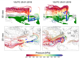
With a week's delay, I'd like to come back to Bjorn's email from the 29th of January, the arcs-like bands of clouds, and the unusually large cloud free regions in between these arcs. We were inspired by very similar conditions in the period 1 to 4 February 2018 during last year's pre-EUREC4A-iso campaign. Actually we were still closely monitoring every single move of our laser spectrometer installed at BCO, fascinated by the freshly recorded tropical isotope signals, when we were caught by surprise by a distinct, unusually strong and steady decrease in the number of heavy isotopes in ambient vapour*. This low anomaly in vapour delta D and delta 18O lasted for several days. Such low delta D and delta18O signals in the tropics pointed us towards an event of strong subsidence bringing down depleted moisture from upper levels into the boundary layer. We thus had a look at back-trajectories that we computed using the 3D wind fields from ECMWF operational analysis data with starting points defined using a vertical stack of 42 positions over BCO from the surface up to 200 hPa (Fig. 1). We wondered whether the air parcels reaching BCO under these very dry free tropospheric conditions showed a different history than those associated with more moist conditions.
Here I would like to compare trajectories from two dates exactly 1 year apart (Fig. 1):
- Moist day: 12 UTC on 29.01.2018, a day, on which 17 cold pools were recorded at BCO. As shown
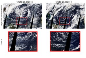
in Fig. 2 left panels, the cloud patterns over the extended EUREC4A domain resembled the sugar and gravel type of organisation mentioned by Sandrine. Ground weather at BCO looked like this: https://barbados.mpimet.mpg.de/bcoweb/archive/weather/1801/WXT_Quicklook_20180129.png
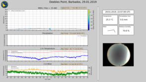
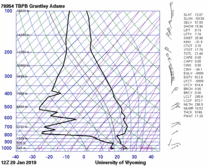
- Dry day: 12 UTC on 29.01.2019, as pointed out by Bjorn a "wickedly" dry lower troposphere was observed on that day along with arc-like cloud structures (Fig. 2, right panels). On that day at BCO we enjoyed the sunny conditions associated with one of the cloud-free arcs: https://barbados.mpimet.mpg.de/bcoweb/archive/weather/1901/WXT_Quicklook_20190129.png
On the “moist day”, the air parcels arriving in the lower troposphere over Barbados (green and blue dots in Fig. 1, left) originated from the eastern North Atlantic, where they subsided over western North Africa within Anticyclone H1 in Fig. 1. These air parcels formed a relatively deep low-level trade-wind layer and stayed at low levels during their entire voyage across the North Atlantic.
In contrast to this, on the ”dry day”, we observed a pronounced and comparatively rapid direct descent (~150 hPa/4days) towards BCO from the extratropical mid troposphere within anticyclone H2 (Fig. 1, right). In this flow configuration, the typical trade wind regime is transiently interrupted.
Compared to the wet day’s synoptic conditions, the striking difference on the dry day is the southwestward shift of the upper-level midlatitude jet (brown contours in Fig. 1) and the strong western Atlantic surface Anticyclone (H2). Note that on both days the air parcels arrived from the east to north-east near the surface. The air parcels arriving in the boundary layer on the dry intrusion day recurved towards Barbados a few hundred kilometers to the northeast of the Island.
In the past months, we have been looking at the air parcel’s history and the synoptic flow configuration of many cases of “wet” and “dry” days from last year’s pre-EUREC4A campaign. One observation we have consistently made, is that extratropical dry intrusions are associated with a different type of cloud organisation compared to the typical trade wind flows. But how do these large-scale forcing factors (jet stream location, strong descending motion from the extratropics, western Atlantic Anticyclone) interact with mesoscale flow features and shallow convection? That’s what we dream to learn more about from EUREC4A, and hopefully isotopes are going to help us to address this fascinating question.
Best wishes
Franziska
*Next Sunday, we will write more about the isotope community's specific research questions and plans with respect to EUREC4A.
