16 Feb
My current interest is on the diurnal cycle of oceanic trade-wind cumulus clouds in the region of Barbados. Scientists I spoke to recently were quite surprised at first. It is often thought that the diurnal cycle of shallow cumulus clouds and convection over the ocean is very weak. Yet, data collected during the BOMEX and ATEX field experiments have made important contributions to the discovery of this diurnal cycle. This was about 30 years ago, but since then this topic has received very little attention, so that our knowledge of the diurnal processes in this fair-weather oceanic cumulus regime and their influence on climate at broader scales remains extremely limited.
Luckily, the excitement around the NARVAL and EUREC4A campaigns has made it possible (among other things) to rediscover this diurnal cycle and to document it with a lot more details than what could be done 30 years ago.
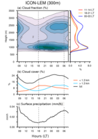
The figures attached illustrates how typically the shallow cumulus cloud field evolves during a day. These results are from the ICON-LEM simulations, which were performed in support of the NARVAL flight campaign in December 2013 (thanks to Daniel Klocke and Matthias Brueck for making the simulations). Longer term statistics from observations (ground-based at BCO and geostationary satellite data) also support these model results.
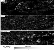
Generally, we see two distinct types of clouds (Fig. 1b and Fig. 2). A population of very shallow cumulus clouds (with tops below 1.5 km), which develops during daytime hours, peaks at sunset (18LT) and dissipates throughout the overnight period. While during the night, the cloud field is dominated by deeper cumuli with stratiform outflow below the inversion (at around 3.5 km), which peak at early morning hours before sunrise. Precipitation is strongly connected to the diurnal evolution of the deeper cumuli, with a minimum in the late afternoon and a maximum in the early morning (compare the blue curve in Fig. 1b and Fig. 1c).
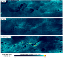
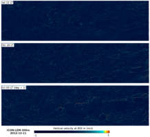
Spatial organization has been a big topic in the past emails. We see here that it varies strongly across the day as a function of cloud type (Fig. 2 to 4). In the very shallow cumulus regime, clouds are numerous, small and scattered – similarly distributed as in the “Sugar” pattern (see Sandrine’s email). While deeper cumuli are fewer, larger and more clustered. The latter organization could be classified as the “Gravel” pattern, which characterizes a cold-pool organized cloud field - as we see here with arcs of upward motion and clouds on the edge of (sometimes) extensive cold pools.
I hope, through this study, to revive this old topic, which can have far-reaching implications. For instance, Raphaela talked about the importance of measuring the coupling between convective mixing, surface fluxes and cloud radiative effects during EUREC4A if we want to better constrain the variations in cloud-base cloud fraction – and by this the shallow cloud feedback in response to global warming. Preliminary results are showing here that some of the diurnal processes simulated with ICON seem to be strongly tied to this coupling between convection and radiation. This diurnal cycle could therefore be used as a testbed during EUREC4A for evaluating the cloud feedback mechanisms that are simulated by global climate models. But for this to happen, we would need a few more flights... at nighttime... If someone teach me how to pilot, I'm happy to wake up in the middle of the night to do the measurements!
Cheers,
Jessica

(a) Vertical distribution of cloud fraction and averaged profiles for selected times. (b) Total cloud cover (black) and contributions from clouds below 1.3 km (orange) and clouds above 1.3 km (cyan). (c) Surface precipitation.


