11 Feb
Did you ever wonder how many clouds pass over Barbados during an average pre-EUREC4A period? Or how many clouds overall we have measured in the past?
To beginn counting, we need to identify individual clouds. This is done with cloud radar measurements. The reflectivity is converted into a cloud mask and then segmented into these cloud objects. From these objects, additional macrophysical parameters (e.g. cloud base height, cloud depth, …) are calculated. We now have an archive of all the clouds that have been measured by radar at the BCO site.
Since the beginning of measurements at the BCO on 22. Dec 2010 until yesterday, 458,249 have been measured.
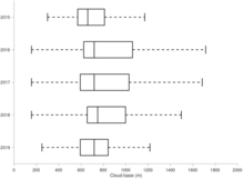
But what about the EUREC4A period? What did past pre-EUREC4A periods look like? Did they all look the same? For this, we will look at the time periods Jan, 20 to Feb, 20 of the last years 2015 to 2019. The number of clouds are pretty constant, ranging between 5067 (in 2016, with a three day measurement gap in-between) and 8252 (in 2018) per EUREC4A period. If we now look at cloud base height over the years (Fig. 1), we see, that the cloud base height has quite a bit variation between the years. Here, we should also keep in mind, that the distribution of cloud base height often is bimodal with one mode for low clouds and one mode for high clouds. Therefore, long whiskers towards the higher values indicate more high clouds (cloud base height > 8000 m). The lowest values of cloud base height originate from precipitating clouds. These haven’t been filtered out yet. The median of cloud base height is relatively constant over the years, which is to be expected since boundary layer depth in the trades doesn’t change much. So we have mainly boundary layer clouds with constant cloud base height. Variation in the distribution originates from the varying number of mid-level and high clouds.
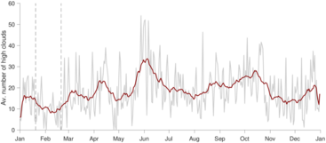
And to come back to Bjorns remark from a few days ago that there were only very little high clouds this year’s pre-EUREC4A: I went looking for high clouds in particular and yes, so far, we had only 162 of those this year on three days (22. Jan, 07./08. Feb). This is a pretty low number compared to last year (596) or the year before (668). But if we look at the annual cycle of the average number of high clouds (Fig. 2), we see, that the EUREC4A period in particular has very low amounts of high clouds. So, if we’d be planning a measurement campaign observing cirrus clouds, this might be a problem. But fortunately, the main focus of EUREC4A cloud observations will be on trade wind cumuli. And in this case, I think we can hope for lots of undisturbed shallow clouds.
I’m looking forward to in finding out, what next year’s conditions during EUREC4A will look like!
Cheers,
Heike


