1 Feb
In the spirit of EUREC4A, we had an expedition with RV Maria S. Merian (MSM) from Cape Verde across the Atlantic with a special maneuver offshore of Barbados. Sounds exiting? It was, not only because we were surfing on the waves with strong tail winds for most of the journey, but because of the beauty of our growing cloud record.
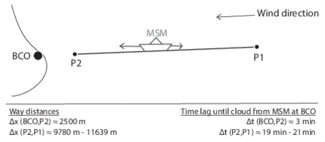
Since more than a year, we are operating a cloud lab on the vessel (images and analyses from the first expedition are available here: https://pure.mpg.de/rest/items/item_3006588_14/component/file_3006589/content). We have equipped the pile deck with a ceilometer and a cloud imager ‚Pinocchio‘ that records sky images in the visible and near infrared spectrum. Last December, we were back for checking the instruments and collecting data for a comparison of the measurements on board with the BCO. For the latter, we have tracked the warm clouds that approached the island with MSM by traveling ourselves with the wind. We first had one travel segment towards BCO in the direction of the wind, turned by 180 degrees for traveling in the opposite direction, and again approached the island with the wind. Each of these three travel segments were 30 minutes long, but we travelled different distances each time due to changes in the relative speed of wind, waves and the ship. Estimates of our distances and the cloud speeds are given in the enclosed sketch (Fig. 1).
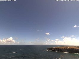
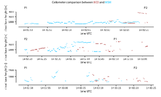
The hope is that the manoveur will help us to understand the cloud development during the transition from the open ocean to the island. We have seen warm low-level clouds in December, similar to the ones in yesterday's video camera at BCO (Fig. 2). Figure 3 shows a preliminary comparison of the ceilometer measurements at BCO (red) and on MSM (blue) in December. We often get similar cloud-base heights, but sometimes the measurements differ. When looking at the time series, keep the time delay (clouds first at MSM) as well as the stretching and squeezing of the time series in the relative system in mind, e.g., MSM sees the same clouds for longer while moving towards BCO. The point measurement of the ceilometers alone do not allow us to completely understand whether the base height has changed or whether we are measuring at the margin of clouds such that we miss the cloud base. One way for resolving it is exploring the cloud images from ‚Pinocchio‘ from MSM and BCO for adding a spatial context. ‚Pinocchio‘ will thereby help in assessing whether the ceilometer gives us a false impression.
During the expedition, we also collected a record of meteorological measurements from the automated weather station, vertical profiles from the radiosondes in kind contribution from the German Weather Service, and a record of the atmospheric composition from remote sensing instruments, e.g. in contribution to NASA’s Maritime Aerosol Network. I show some of the data time series from December in Figure 4, but there are already more applications where the data from the last expedition is useful. For instance, Sabrina Schnitt uses the radiosondes from MSM for better understanding the influence of the land on the tropospheric moisture structure. Stay tuned as she will introduce a first pilot study on the land-sea contrast at Barbados with contributions from different institutes. We will do much more of such collaborations for EUREC4A, and, thanks to the shooting stars at BCO last December, we should have plenty of luck for it.
Yesterday (1.1.2018) a long-lasting stratiform cloud covered the Barbados Cloud Observatory for 2.5 hours. The satellite images didn't show a clear flower pattern as the day before. The cumulus tower passing over the observatory did not seem to have enough energy to contribute to the stratiform layer as it is disconnected and didn't leave a visible footprint in the geostationary satellite data from GOES16.
Nevertheless, the activity south-east of Barbados has been much stronger and a towering cumulus developed out of a cold pool arc and eventually moistened the layer of the stratiform cloud again. In the meanwhile we were capturing the remote part of the stratiform layer at the observatory (see animation at: https://owncloud.gwdg.de/index.php/s/GxAyTURcyxgxspj )
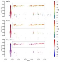
You heard already about the K-Band deployed on the island. Since December 2018 it has a companion in the W-Band at its side.
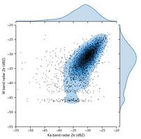
In the attached figure you get a first taste of the different systems capturing the stratiform clouds (for better comparison the data is regridded on an identical time and height grid). The K-band power is clearly superior to the W-band power and for more sensitive targets (smaller droplets/less droplets), the distribution of the W-band radar levels off. The dependence of the reflectivity on the wavelength has some advantages. Sabrina Schnitt will talk about one of them in a later post.
In the context of flowers, it would be interesting to retrieve the cloud droplet size as an interesting quantity to illuminate the mechanisms behind these very thin stratiform layers.
