23 Jan
A friend of min (João Teixeira, many of you may know him) once related the question to me: Imagine that we knew nothing about football (soccer, for the US crowd) and we were tasked with figuring out the rules, but all that we had were snapshots taken from an overpassing drone or satellite, say once per game. Imagine the challenge… well if it were American football it would be worse because with high probability people would conclude it wasn’t a game, rather a costume party… okay the last part was my addition to his story.
So the time dimension is very nice ‽A6 which brings me to today’s entry, which is for Raphaela Vogel, who is on the site, thinking about cold pools (at least I hope so), something she will think about more in Paris where she is going to work with Sandrine in March.
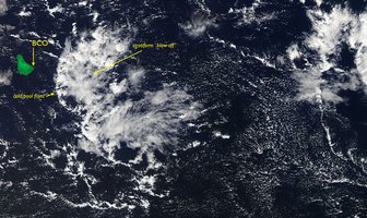
Today in the MODIS imagery I noticed a line of shallow convection, organized in what seemed to be a cold pool front, with associated stratiform blow off approaching our site. The image (A1) is attached, with three annotations: the location of the BCO (Barbados Cloud Observatory), what I see as the cold pool front, and what, for lack of a better term, I call the stratiform blow off.
Now thanks to GOES-R we can look at this in time, here (assuming it works) is the animation. What it shows is that as the convection goes up the precipitation generates what we interpret as a density current that races ahead of the convection, along which a line of clouds form. The precipitation convection overshoots and detrains condensate in what I call the convective blow off.
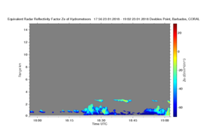
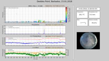
Well this then we can look at using the BCO instrumentation here included as A2. What we see is that at 18:20, coincident with the passage of the convective line, we see the convective line pass it is associate with a sharp change in wind direction, weaker winds (go figure), a small drop in temperature and rise in dew point. And of course a radar signature to the cloud (see also A3). Forty to fifty minutes later we see the generating convective element, or perhaps a new one, emerge over the sight, with precipitation reaching the surface, a sharper reduction in temperature, and this time a wind gust just out ahead of the convection, i.e., the next cold pool. The cloud behind it is a stratiform cloud sheet at about 2.5 km and is quite evident in the radar; it is interesting to see how thin the layer is, and how it even appears more gray in the satellite image (A1). Are these flowers? Well they seem in some ways different, they’re smaller, and seem more like blow off then a stratocumulus layer with their own internal dynamics. ….
Question for the day: How important are these features to the albedo of the tropical ocean, i.e., what would the albedo be without such features? And assuming they aren't just pretty but matter, what regulates their properties and lifetime? … and any hope at all of a climate model with parameterized convection capturing these dynamics?
Follow up on yesterday: We had a rain rate of 150 mm/hr from the (warm rain) shallow convective system at 2am UCT this morning.


