22 Jan
How much rain one can get out of a fairly shallow cloud?
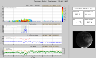
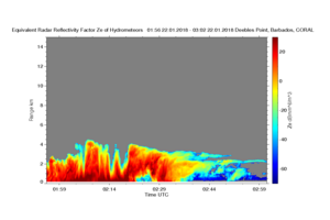
Here Disdro reported 45 mm/h from a cloud whose top was at 4.5 km, i.e., about the height of the freezing level, so all the rain coalesced out of warm-rain microphysical processes. These are fantastic rain rates. Before when we would infer something like this from the cloud radar we would be skeptical due to the Mie-effects on the reflectivities at high-rain rates; but now seeing the optical disdrometer corroboration it seems plausible. In fact, the blow up on the radar shows that during the peak precipitation it was completely attenuated after a few hundred meters (A2), so it was indeed quite some rain.
But more striking was that this was the smack of a fish's tail. Basically the mesoscale feature, our Fish from yesterday, moved over Barbados and into the Caribbean where it drifted toward the continent and interacted with flow off the continent to produce a very deep convective flare just west of Grenada, or about 250-300 km west of Barbados. This first flared at around 19UTC, and seven hours later we saw things happening on Barbados (i.e., which is how long it would take to travel 250 km at 10m/)s, makes you wonder if it was connected. The cirrus blow-off of the convection comes over the sight at about 14 UTC, topping at 12.5 km and is visible in the radar imagery now (not shown). Here the GOES imagery is helpful: (http://rammb-slider.cira.colostate.edu/?sat=goes-16&sec=full_disk&x=15407.8759765625&y=7854&z=3&im=60&ts=2&st=0&et=0&speed=130&motion=loop&map=1&lat=0&p[0]=9&opacity[0]=1&hidden[0]=0&pause=0&slider=-1&hide_controls=1&mouse_draw=0&s=rammb-slider) Shows the 7.3 micron channel which is weighted toward lower tropospheric moisture.
That said the satellite presentation of the convection over Barbados is not spectacular, and it seems that the convective feature coming up along the back of the fish could have just been a relatively normal feature embedded in or interacting with the somewhat moister mesoscale environment that had encapsulated the fish.
One question for today is how much do these moist blobs, in which this particular fish lived, generate a circulation to help maintain, or even amplify their own moisture, and how much is just passive advection of moisture features that get pulled down from moister regions in the North (in this case) or the south (in other cases?). Another question is to what extent these features are captured by precipitation climatologies (hence the cc to Seiji Kato who has been asking this question himself) Maybe they are part of the missing 10%? Well for features like today it would also have been very nice to have Poldirad in operation, the DLR C-band radar, which would have allowed us to better look at the evolution of the precipitation system as it moved toward and over the island, map out the maximum cloud tops, and so on.
If Martin has success perhaps PoldiRad makes a star appearance for EUREC4A And as for a prediction? Well there are lots of cold pool mesoscale convective features out there, but it seems that the chance of getting hit are not great, so I predict not much in the way of convective features for the coming 24 hours, and maybe a more marked contrast in the moisture profile, i.e., we can contrast the 2 am Raman moisture profile from this morning with that of tomorrow morning and see how variable the lower tropospheric moisture is… more on Day 4.


