15 Feb
Today I thought I got a cloud present, as there were nice cloud detritus at 4 km and 6 km. I keep wondering how much ice we have, and at what altitude it sets in. The way some people talk it seems like the atmosphere has a very hard time forming ice, and while I am sure this is true at times, it never seems to not snow if it wants to. In any case, in the hopes of hunting for ice in the trades we put our other radar, which we call Katrin (we have two Metek systems operating at the moment), looking upwind with a sixty-degree inclination. My hope was that we might get a better polarization signal.
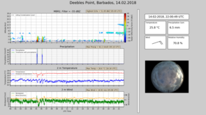
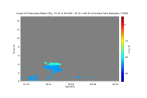
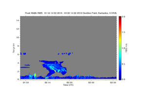
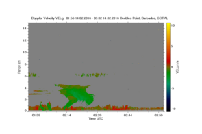
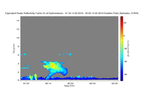
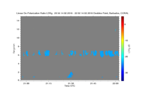
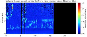
Well today when I saw the image (A1 upper panel in the quick looks I got excited by the clouds near 6 km in the early morning hours. It turns out that the small features at 6 km were difficult to see in the depolarization as we did not get enough return, but looking at the lidar depolarization (A2), there seemed to be ice in the feature popping out near 4km, where freezing level is at about 620 hPa say around 4=m. Turning my attention to the radar, and in the spirit of exploring what the radar can show us, I attach the reflectivity, vertical velocity, linear depolarization and the spectral width images in (A3-A6). Well the depolarization signal is fantastic, and we see plenty of ice from this turret that doesn’t go much above 4.5 km! It is a great signal as it makes sense also in the other moments of the doppler spectra, as fall velocities increase below the melting level and there is some doppler broadening near the triple point.
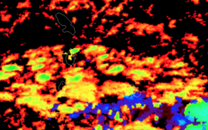
So is ice that easy to make… well looking further, at the GOES-16 it seems the feature we are seeing is part of deeper convection in the area, which was also responsible for the detritus at 6 km, shown in (A6, where green is at 6 km). Temperatures at 6 km are -10, and there is a very strong capping inversion a little bit above that, so the cloud tops were unlikely much colder than -17 degC … as far as aerosols are concerned the air is clean as a bat … well I don’t know if bats are clean, and one confounding feature is much deeper convection to the south, that is edging its way on the scene. It shows up in the GOES in the blue colors also over the site at 2:15, but we don’t see a sign of it, at least not until now where it is poking its anvil into our radar image at 12 km around 22 UTC … and to make things even more interesting, later in the day when we have much more cloud between 6-8 km it all seems super cooled.
Any radar experts** want to chime in on my interpretation?
In any case as it turns out we didn’t need Katrin to look out the corner of her eye to see the ice. What I would like to know is how often we see ice as a function of the depth of the convection.
** thanks to Pavlos for suggesting to look at the shear in the doppler velocities, as if it correlates with the doppler spectral width then we are probably seeing large scale effects.
